The Long-Term Strategic Plan for Rail's patronage growth and service and infrastructure response analyses summarised in section 4 of this report point very clearly to one critically important project for the decade starting in 2011: a new alternative route through the CBD, linking Eveleigh and St Leonards via the CBD and North Sydney (see sections 4.3 and 4.4).
A series of other projects to further amplify the capacity of key rail corridors as growth continues will also be essential.
The other projects likely to be required between 2011 and 2021 will, however, be much more a matter of choice. They will be driven by a wide range of considerations, extending well beyond (but still including) "rail system viability" considerations and including new urban development locations and patterns, the densities of development in new and existing urban areas, the longer-term development of bus transitways and the potential of different rail projects to reduce road demand growth. There will need to be close liaison between the rail agencies, the Department of Transport, the Department of Urban Affairs and Planning, the Roads and Traffic Authority and all other stakeholders in the planning and prioritisation of these projects.
Extending the rail system's "reach"
In particular, it will be highly desirable to extend the "reach" of the metropolitan rail system by building new lines into existing and new urban areas that are distant from the existing network, especially in northwestern and southwestern Sydney.
This approach was expressly recognised in Action for Transport 2010, which included announcements of the new Epping-Castle Hill-Mungerie Park line and longer-term Warringah and Bondi Junction-Maroubra lines.
Unless the "reach" of the rail system is extended in this way, Sydney will be doomed to a future under which more than half the urbanised metropolitan area, and especially those areas at more distant locations, will not be served by the rail system, creating and reinforcing significant inequalities in access to employment, education and other community facilities.
The construction of new "greenfield" railways has important implications for the operation and capacity of the existing rail system, and highlights the importance of the principles of "sectorisation" and service segregation which have already been a key focus of proposals for the decade to 2011 (see section 4.4.)
Indeed, as already explained in the context of proposals for further upgrades to and from the Illawarra and the Central Coast, the Long-Term Strategic Plan for Rail envisages the deferral of a number of important "reach"-extending projects until the capacity and operational robustness necessary to accommodate the new services can be provided. Unless this is done, the "reach" extending projects would simply feed more trains into a strangulated and highly unreliable network.
The factors influencing the types, locations and timings of future new railways have been listed in section 3 of this report, and are considered in detail in the Long-Term Strategic Plan for Rail.
Although there are obviously some significant uncertainties about the future shape and nature of the greater Sydney metropolis, it seems clear that the two "reach"-extending projects warranting the highest priority will be:
The general approach adopted by the Long-Term Strategic Plan for Rail in considering possible future cross-regional and "greenfield" railways is that in many cases alternative intermediate public transport modes should be used at the outset, especially road and "transitway"-based bus services, with rail modes being adopted for a corridor only when its demand is expected to reach (say) 5,000 people per hour during peak flows and when the much higher speeds and capacities of heavy rail become important or when constraints such as road congestion prevent buses from fulfilling their transport tasks.
This is consistent with the strong emphasis in Action for Transport 2010 on the rapid development of a bus transitway network, not just for both cross-regional links and "greenfield" corridors, with rail being a longer term option.
The application of this principle of choosing the most appropriate mode of public transport for the demand means, however, that some previously envisaged medium-term cross-regional rail links, including the Hurstville-Strathfield railway announced in Action for Transport 2010, are unlikely to need to be provided as heavy rail links until the long term, if at all. The Hurstville-Strathfield link would instead be developed first through the provision of high-quality cross-regional bus services, potentially with dedicated bus lanes as demand develops, and then through a transitway-style bus corridor, moving to rail modes only if and when higher speeds and capacities are required.
A large number of possible new rail links and augmentations of the existing network are considered in the Long-Term Strategic Plan for Rail, in corridors focussing on both the Sydney CBD and Parramatta.
Initial selections have been made of the projects believed to have the greatest merit at this stage.
While there will obviously be changes in projects and priorities as the future unfolds in unanticipated ways, new ideas are presented and detailed investigations are carried out, the longer-term vision for the rail network presented through these selections--ultimately for a metropolis of some five or six million people--provides an important planning context for all future transport developments in the region, essentially in the same way as DMR/RTA plans of a similar nature in the 1940s and 1950s have provided a context for most major road network planning in the last 50 years.
This is not a new philosophy for rail. The architect of much of the current metropolitan rail network, Dr Bradfield, adopted a similar approach, very successfully, in the 1920s and 1930s. The "unusual" nature of presenting a longer term rail vision is simply an artefact of the dominance of road planning in the last 50 years.
Figures 5.1, 5.2, 5.3, 5.4 and 5.5 present increasingly indicative concepts of the rail network developments that will need to have occurred during the five-year periods to 2006, 2011 and 2016--as discussed in sections 4.4 and 4.5--and the developments that are expected to have occurred during the subsequent periods to 2021 and (say) 2051.
With the exception of the vitally important new route through the CBD, the timing of projects during the five year periods to 2016 and 2021 is reasonably flexible. For example, if funding were available, some of the projects shown for 2016-2021 (Figure 5.5) could be carried out earlier, provided this does not jeopardise the completion of the new route through the CBD.
Figures 5.6, 5.7 and 5.8 assemble the projects shown in Figures 5.1 to 5.5 into "snapshots" of the existing rail network, the rail network in 20 years and the rail network in about 40-50 years, serving a metropolis of approximately 5-6 million people.
The vision presented in these longer-term concepts is not intended to be prescriptive. Rather, it is intended to:
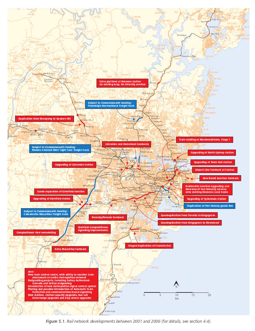
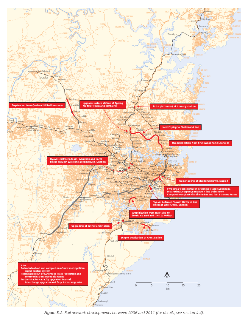
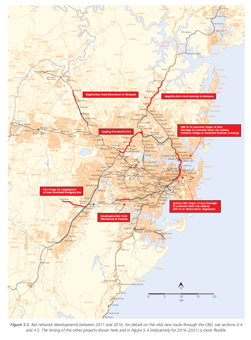
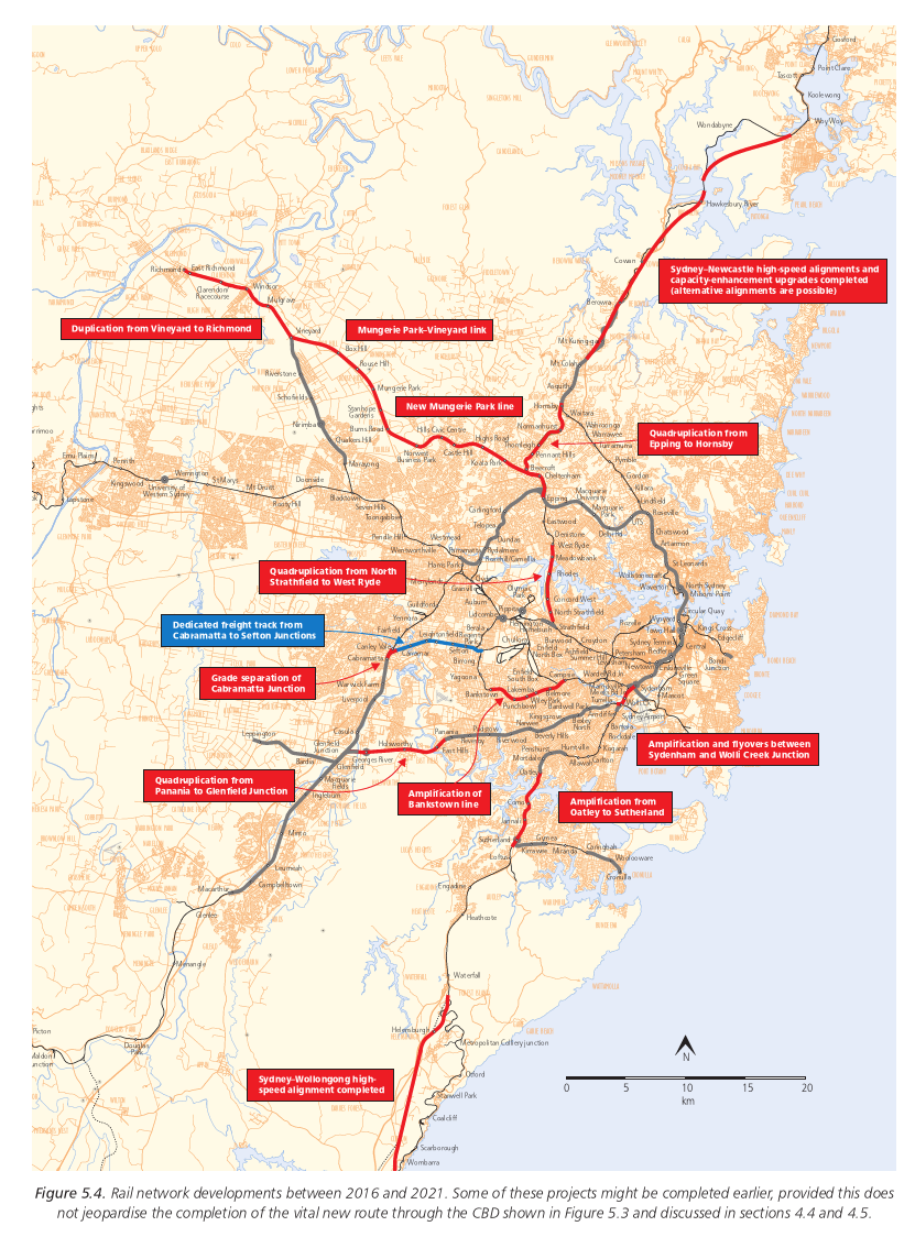
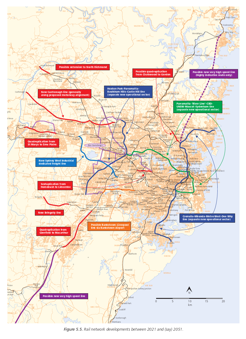
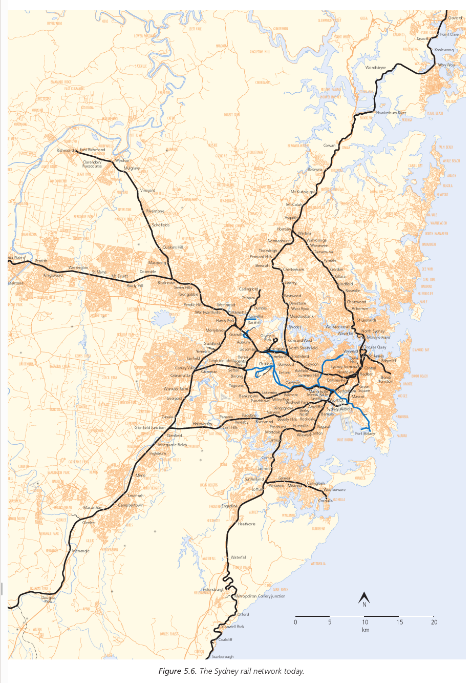
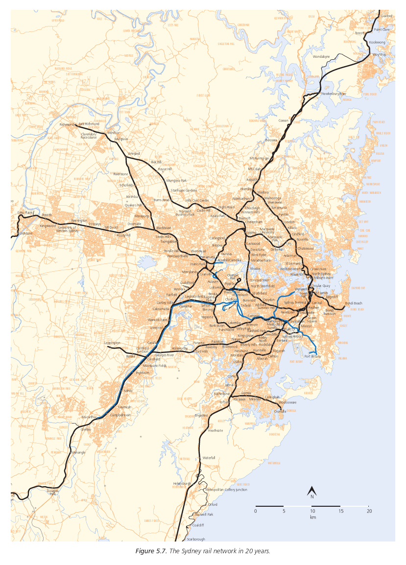
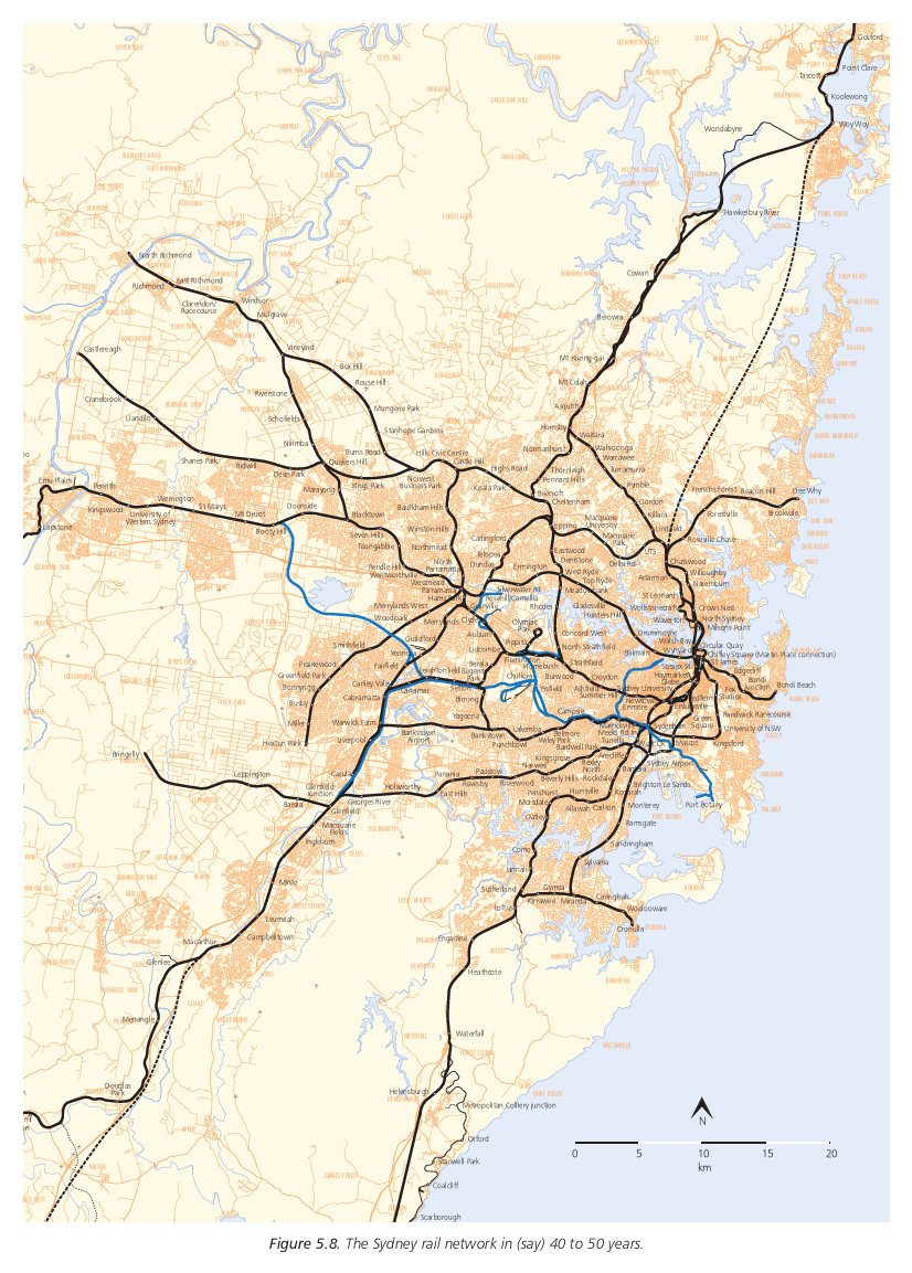
Figure 5.5 and 5.8, showing possible long-term projects beyond the next 20 years, include three entirely new railway routes, each operating independently of the existing rail network and each creating an entirely new operational "sector":
The physical separation of these (or similar) new lines from the existing rail network (and from its augmentations and extensions over the next two decades) is an important principle and vital to the long-term future of rail.
It is likely that by around 2020 (Figure 5.7), even with all the augmentations and extensions discussed in this report, including new signalling systems etc, the existing rail system will simply be unable to absorb any additional traffic created by the connection of any more new lines. Even if the capacity were theoretically available, the separation and "sectorisation" of different types of rail services would once again be placed under severe strain, jeopardising service quality, efficiency and reliability.
The solution of physically separating the new lines as much as possible, as illustrated in Figures 5.5 and 5.8, is already widely practised in large cities overseas which have been faced with analogous situations.
As indicated in section 4.3, it is possible that new, separated routes such as these, involving long lengths of tunnels, utilising the new high-capacity signalling systems which by then will be firmly established and passing through what will by then be relatively high-density urban and employment areas, might best be served by fast, high-frequency, highpowered, single-deck "metro"-style trains, albeit with more seating than traditional metros.
The additional benefits of this approach would include greater flexibility in choosing the alignments to maximise patronage and the railway's accessibility and land-use benefits and greatly reduced construction costs.
The precise routes of any such lines are obviously still to be determined, but the general principle is that they would be built in stages, reflecting the growth in patronage demand (both within the existing urban areas as higher density development continues and in greenfield areas) and the capacity constraints of the existing network (for example, the "River line" component of the Parramatta-Sydenham line, from Parramatta to the CBD, would help relieve long-term overcrowding of the Main West line, which will ultimately return as a major problem even with the track amplifications shown in Figure 5.5).
These types of proposals are not casually drawn "lines on maps". Like road developments, they are based on analyses of future patronage demand, land uses, etc. But unlike road developments, they are also heavily based on practically oriented operational studies, to ensure train services will be able to be provided to CityRail's customers using operational patterns which reflect not only their own travel needs and desires but the practical limitations of a complex rail system (trains, unlike cars, not being able to simply go where they please).
For example, although Figures 5.5 and 5.8 suggest it is worth investigating a heavy rail link between Bankstown and Liverpool via Bankstown Airport, if such a line were integrated into the rest of the network it might cause severe operational complexities, and alternative and cheaper public transport modes might well be desirable for this reason (and also, quite possibly, because of the future level of patronage demand).
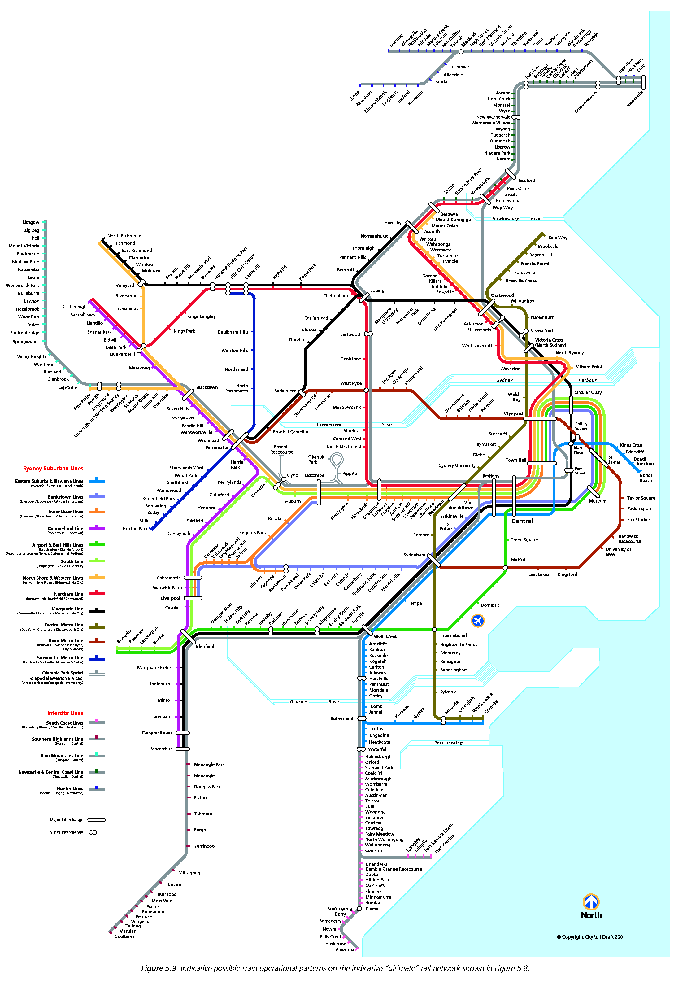
Figure 5.9 shows some preliminary concepts for the rail services that might realistically be able to be provided, consistent with the emphasis on greater "sectorisation" to ensure service reliability, with the "ultimate" rail network shown in Figure 5.8.
Figure 5.9 suggests that while there will inevitably be much more
interchanging between different train services as the complexity and
density of the network increases, it should still be possible, with a
network designed on the basis of operational viability, to provide
"end to end" services, without interchanging, that will meet the
travel needs of most CityRail customers.
The suburban services suggested in Figure 5.9 are: